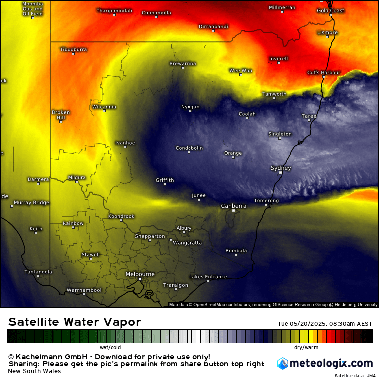
For some days now we’ve been on the dividing line between drier weather to our north and much wetter weather to our south. That’s the theme as well today – but we’ve also got a transient small surface low moving in to add to the mix – result is a dynamic day coming up.
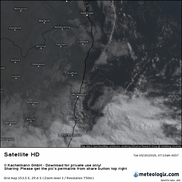
A quick look at the water vapour image this morning highlights the divide – blue is wet, red is dry, and we’re right on the boundary:
And sure enough look at the rain since 9am yesterday and you can see the huge falls already down south, with close on a quarter of a metre in some locations:
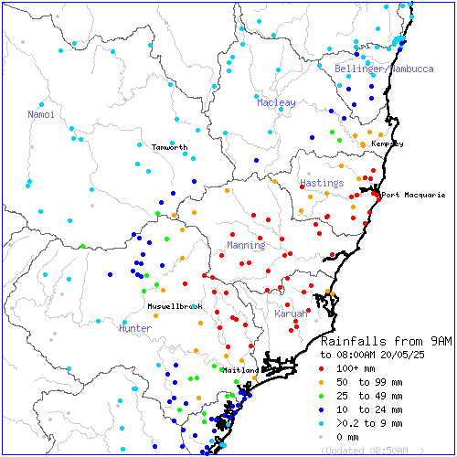
Needless to say we’ve got some rivers in major flood through the Hunter and Lower MNC with SES emergency warnings to our south:

The trough responsible is moving slowly north. It will then grind to a halt before heading south / offshore later in the week. We’re close to the northern extreme of the forecast resultant rain – meaning a few km north or south can have a big impact in the rain totals we’ll see. As such it’s hard, even at such a short time frame, to know how much we’ll see. There will be big falls today along the Mid North Coast – we could catch the northern end and see some big totals or they could remain *just* to our south and we’ll see showers but nothing too significant. To add to the mix a transient small area of low pressure has formed in the trough off the Coffs Coast and is moving closer to shore. You can see it in the morning satellite imagery:
You can see the winds converging in the image below:
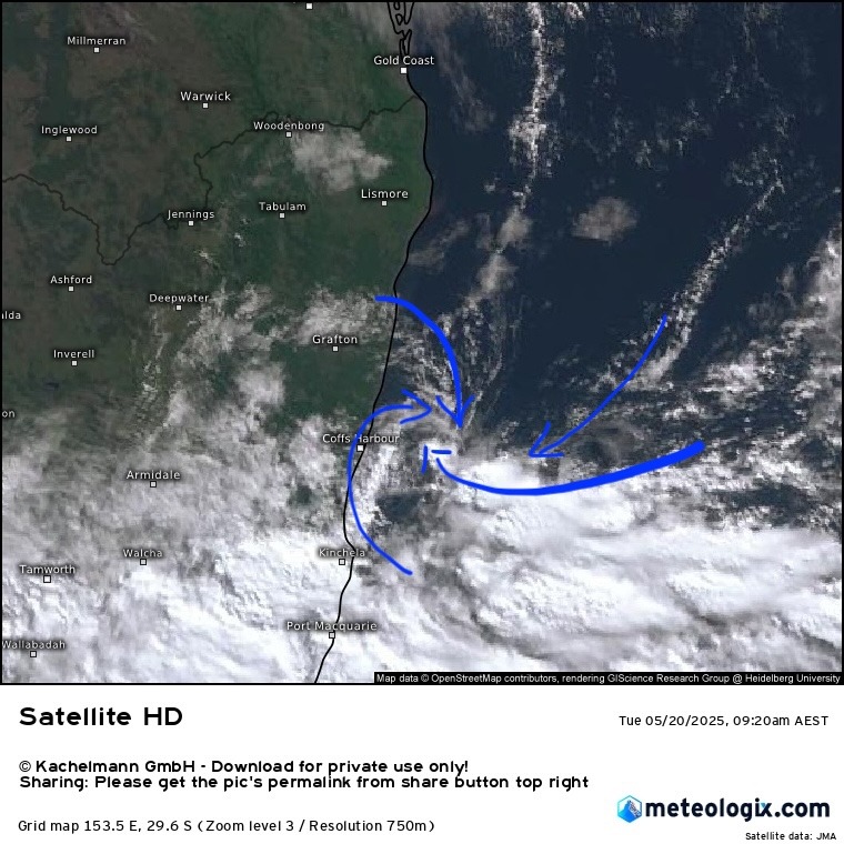
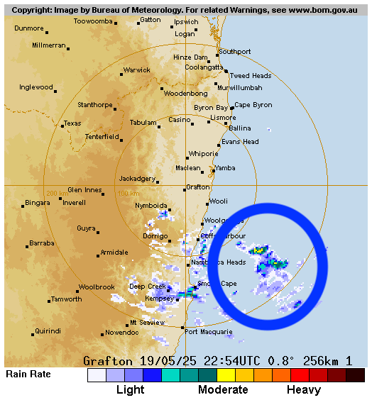
That system will move ashore through this morning very close to our region. Anyone to the north will see drier offshore winds for a time, but conversely anyone just to the south of the centre will see some intense falls and potentially strong winds as it moves ashore. You can see the system approach in the image above but also in the Grafton radar – I’ve highlighted it in the image below:
The BoM warning picks up the potential for some significant falls through today:
Prolonged moderate rainfall with isolated areas of HEAVY RAINFALL which may lead to FLASH FLOODING is forecast to continue for parts of the Mid North Coast, northern Hunter and adjacent parts of the North West Slopes & Plains and Northern Tablelands districts. Six-hourly rainfall totals between 60 and 100 mm are likely. 24-hourly rainfall totals between 90 and 130 mm are likely. Moderate to HEAVY RAINFALL is forecast to shift further north into the Mid North Coast during Tuesday, possibly continuing into Wednesday.
Locally INTENSE RAINFALL which may lead to DANGEROUS AND LIFE-THREATENING FLASH FLOODING is also possible during this period with persistent heavy showers and isolated thunderstorms over coastal areas between Seal Rocks and Nambucca Heads, as well as inland elevated parts of the Mid North Coast district. Six-hourly rainfall totals between 100 and 190 mm are possible. 24-hourly rainfall totals between 160 and 230 mm are possible.
The most intense rain and storms will come ashore just south of that small low pressure system…definitely worth keeping an eye on the radar this morning as those more intense downpours will come ashore close to our region. With significant totals already fallen the models are highlighting how much more the Mid North Coast will see over the next two days:

The strong south easterly winds are also bringing some coastal impacts:
DAMAGING SURF CONDITIONS are possible between The Entrance to south of Port Macquarie, extending to south of Coffs Harbour Tuesday morning. These conditions may lead to localised damage and coastal erosion.
In summary – big falls and significant flooding likely to continue / increase across the Mid North Coast through the middle of this week. We’re close to the northern edge so totals hard to predict for us, however big falls remain a real risk if the focus moves just a few km to the north. On top of that mix a small low is moving close to the Coffs Coast this morning – drier (for a time) weather to it’s north, but very heavy rain likely just to the south of the centre as it moves ashore. Once again we’re borderline for the heavier rain but the potential is definitely there. Worth keeping an eye on the radar and BoM warnings through today – and not a good day to travel south! The local Floodcams could be useful if we do see heavier falls.