Starting off long term and then looking short term…and (with thanks to Yale Climate Connections, whose words I’m adapting below) multiple studies now suggest that human-caused climate change is boosting an atmospheric pattern in the North Pacific that favours wetter weather across the eastern seaboard of Australia.
This weather pattern – known as a negative mode of the Pacific Decadal Oscillation, or PDO – is one phase of a slow-moving swing between warm and cool temperatures in the northeast and tropical Pacific Ocean. The PDO’s monthly value for July was the lowest in 171 years of data:
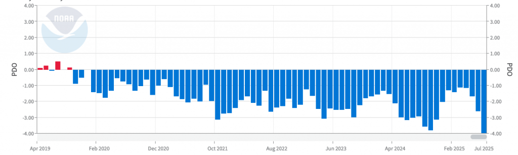
You can see the PDO sitting in the positive in 2019 – the year of fire…before turning negative, where it has sat ever since. The -4 reading for last month was, as stated above, the lowest in over 170 years – and is a big deal. The PDO is often described as a long-lived El Niño / La Nina-like pattern – so when it gets wet (or dry) it tends to sit there for some time. Using new techniques to extract signal from noise in model output, the researchers found that “observed PDO impacts can be largely attributed to human activity”.
If this is the case it’s a big deal for us as it significantly increases the risk of La Nina events over a much longer period of time. It does NOT mean it’s wet all the time, or that we sit with La Nina conditions right through – in fact we’ll still see El Nino / drier conditions from time to time, with those times potentially lasting a year or more…but while the PDO sits in the negative El Nino’s will remain less likely (and possibly of a shorter duration) and wetter conditions will be a lot more likely to occur.
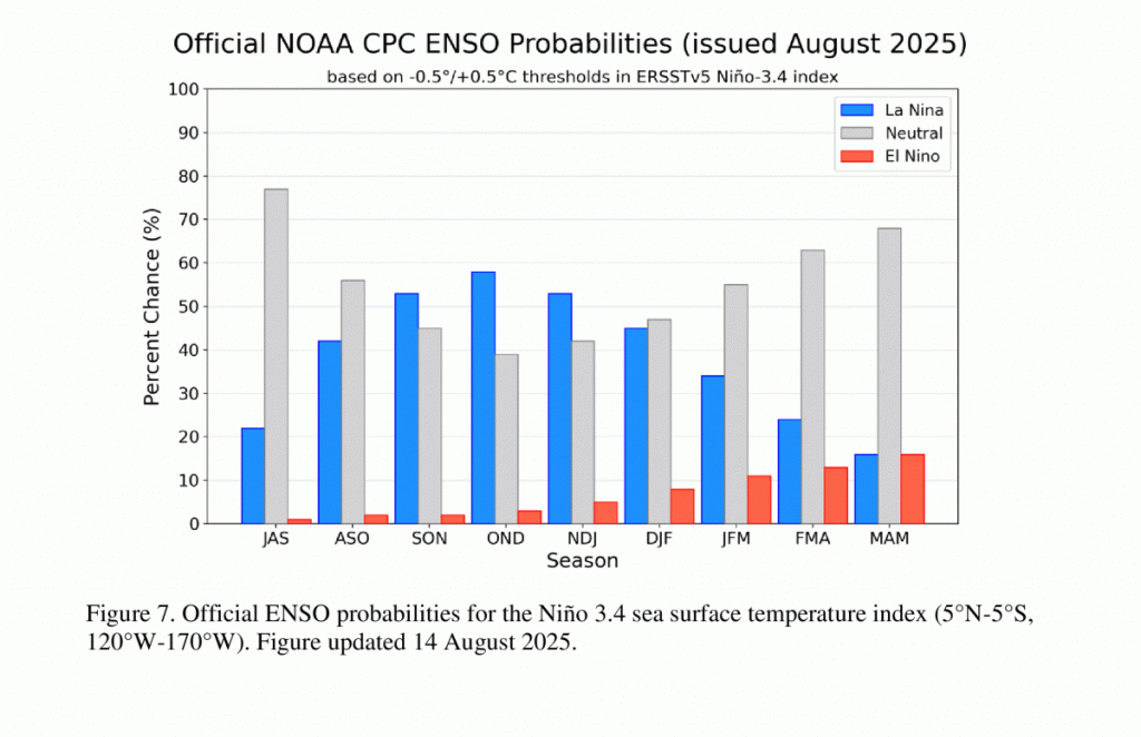
It might thus come as less of a surprise to see forecasts indicating the risk of another La Nina event this spring / summer. The latest forecast from NOAA takes those odds as close to 60%:
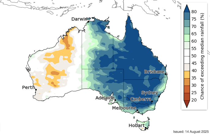
…which fits with the forecast of wetter than normal conditions from the BoM through our spring:
…so get prepared for the risk of more wetter than average conditions as we head into this spring / summer. Before I jump into the coming week going to push even further ahead into the following year – and models are indicating a (based on the above likely shorter-lasting) push towards much drier conditions for the following spring. If you look at the sequence below…
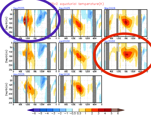
…you can see cooler subsurface temperatures below the eastern Pacific next month (blue circle added around the image) – these anomalies should surface through spring and bring La Nina-like conditions across the Pacific…but look forward towards next winter (red circle) and you can see completely different sub surface conditions with much warmer than average below-surface ocean temperatures across the eastern Pacific…which would likely surface over time and bring more El Nino-like conditions.
Going to flag here that (1) the forecast for next April is a LONG way off and could well change (2) even if we do see it play out as forecast it doesn’t guarantee an El Nino (3) even if we do see an El Nino it doesn’t guarantee drier conditions (4) and climate change is making these longer forecasts a lot harder to pin down…but posting here as we’ve seen a lot of the wet recently so a drier period shouldn’t come as too much of a surprise. The persistent wet has helped generate a heap of growth in the bush across our region so fire risk may become an issue if / when drier conditions materialise.
With the negative PDO however any drier years are likely to be in the minority – so as long as it doesn’t get too dry enjoy them while you can.
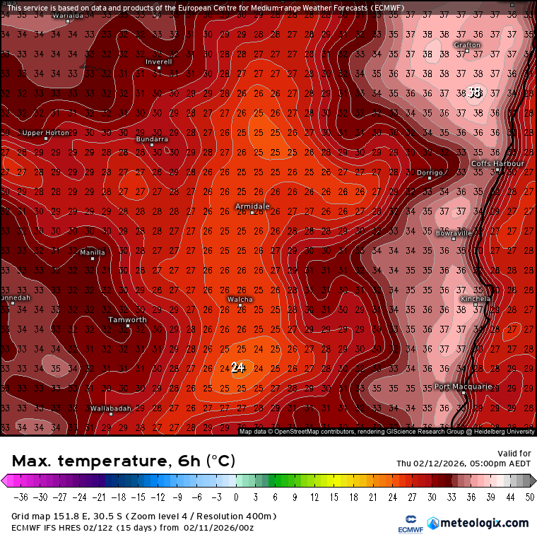
Talking of wet – coming back into the shorter term and it looks like an upper cold pool will once again move across northern NSW through the middle of next week:
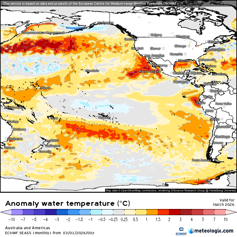
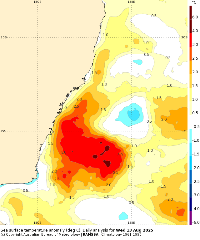
…and once again the combination of onshore winds and above average ocean temperatures will increase the risk of more wet weather across eastern NSW through the middle of next week. Models are just starting to align on this upcoming event, but right now it’s too early to know how much rain we’ll see across our region. With ocean temperatures off parts of the NSW hitting 4c above average there’s a heap more energy available than we’d normally see at this time of year:
This increases the chance of heavier falls – but where they end up (which might even be over the ocean if the system forms further east) is not yet clear. With a cold pool moving overhead snow is a possibility in the usual places – something else to keep an eye on. I’ll post again late weekend as models settle down – until then hope you get to enjoy the sunshine 🙂