We’ve had some showers and storms move through late yesterday, and that heralds a change in the weather. The oceans warm more slowly than the land, then cool more slowly in autumn – simply because water needs a lot more energy (sun, heat) than air to warm up – and thus also has to release a lot more energy to cool down…which takes longer.
Breaking it down seasonally that means we have:
Winter – both ocean and land are cooler [cooler and drier weather]
Spring – oceans still cool but the land is warming quickly [so can be hotter and drier time of the year – not much energy coming off the oceans but a lot of heat over the dry land]
Summer – land and oceans warmer [so hotter more humid weather is likely, with increasing chances of wetter weather]
Autumn with cooler land but still warm oceans [so showers and rain more likely with onshore winds as the warm wet ocean air runs in under cooling upper temps over land].
We can of course get wetter weather in drier seasons, drier weather in wet seasons and the same with temperatures…but over time it averages out pretty much as detailed above.
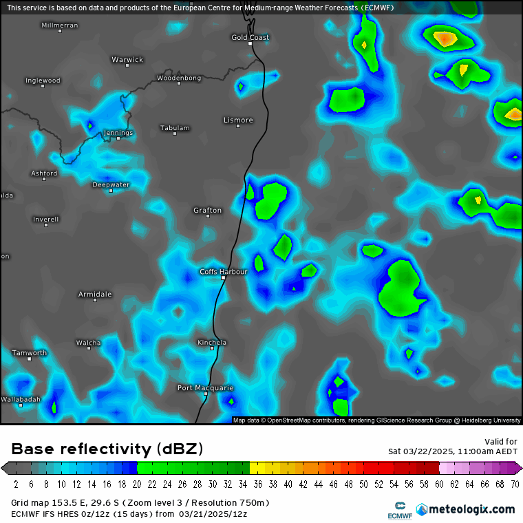
Right now we’re into autumn…and have those oceans showers forecast to move onshore at times right through the coming week. if we look at the forecast radar (12 hourly intervals over 9 days) we can see very few times when showers were not too far away:
There will likely be some wetter spells at times as bands of showers merge into some longer wetter weather, and just as many drier spells with some good sunshine. At this stage we’re not looking at anything like the totals we saw from Alfred a couple of weeks back…though saying that the ground is now saturated so we could see some river rises with any heavier showers. Rain totals vary from model to model, as is usually the case with showers, but averaged across the models over the coming 9 days it comes out like this:
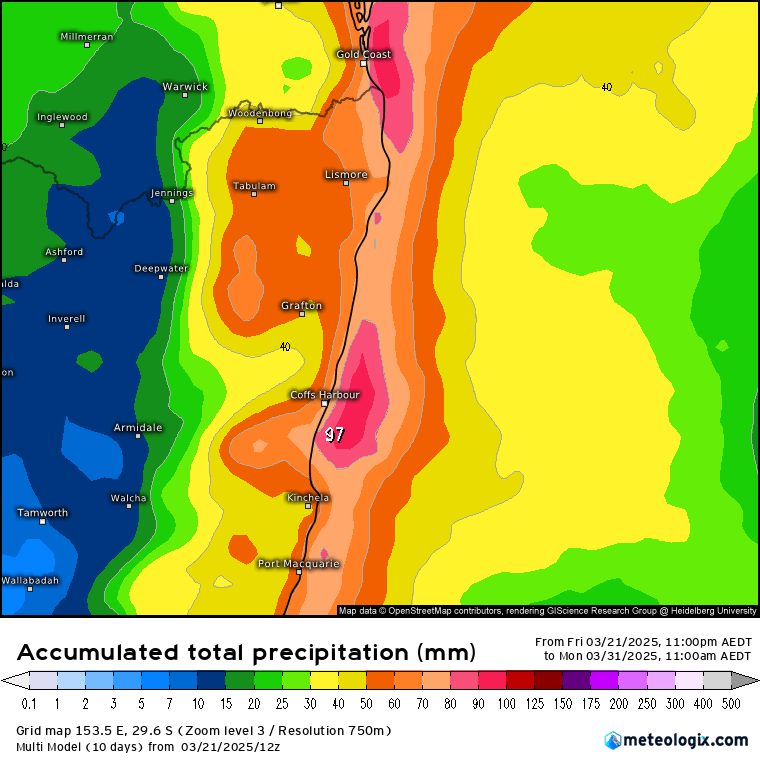
Worth noting that the global models tend to blur out the impacts of our hills and mountains a little so we could see higher point totals in the usual locations. Likewise we’ll also see some sunshine at times as well – a bit of everything.
With an active tropical period to our north inland Queensland in particular could see some very wet weather over the coming week, with moisture streaming south from a very warm Gulf of Carpentaria. Totals across inland Queensland could be half a metre or more, guaranteeing some decent flooding as well as some significant flows down south into Kati Thanda (Lake Eyre) over coming months:
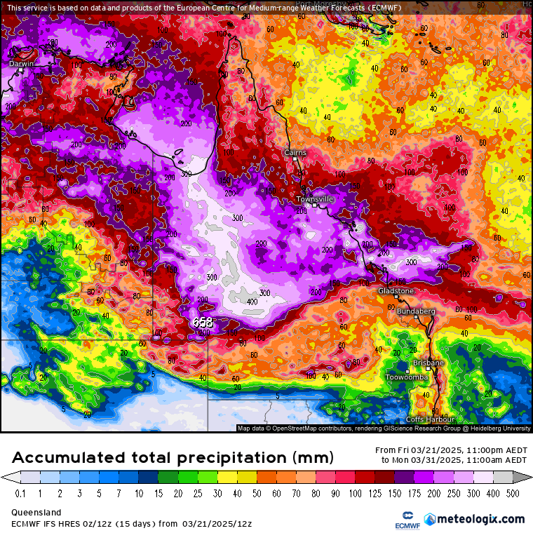

Amazing to think that very little of that rain will make it directly into the ocean! Going to be some more incredible flora and fauna across the inland over coming months – just need to hope that the flooding across the inland isn’t too impactful.
Looking further ahead and we’re in the period of the year where it can be hard to ascertain what the Pacific will do through the remainder of the year. This is because small changes at this time of year can multiply into more significant changes over the following months. As an example one ensemble model (NMME) shows these forecast ocean temperature anomalies for November:
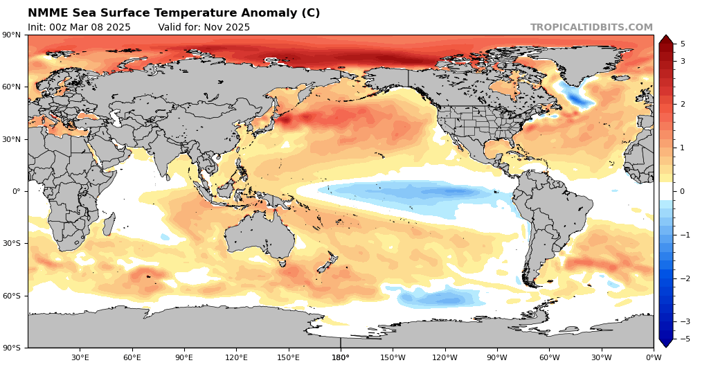
You can easily see the forecast cold pool / La Nina type pattern across the eastern Pacific. Check other models however – for example this is the American GFS model – and you can see the cold pool is completely gone with much warmer anomalies / El Nino type pattern across the same region:
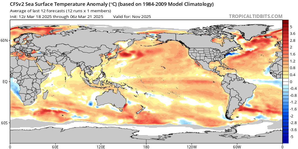
What this tells us is that, as is common for this time of the year, we can’t be certain of what we’ll see later in the year. An outcome like the NMME model would usually result in wetter weather across our region through summer, while a GFS outcome would usually mean drier and hotter weather. I’ll post updates as the models settle on a more likely outcome…
I’ll post again if higher totals look likely from this wetter spell, but for now thanks to the usual awesome sites for their images, and to our sponsors hosts for supporting this site 🙂


